Wildfire activity is increasing in western Canada due to a warming climate, historic fire suppression efforts, and the accumulation of dead-standing timber caused by mountain pine beetle (Dendroctonus ponderosae; Daniels et al., 2025; Haughian et al., 2012; Parisien et al., 2020, 2023; Pausas & Keeley, 2021). These factors are promoting the rapid shift of fire regimes that is reflected in more frequent and severe wildfires and longer wildfire seasons (Flannigan et al., 2000; Haughian et al., 2012). Within British Columbia (B.C.), the increases in the size, frequency, severity, and season length of wildfires are expected to be greatest in the southern interior of the province, causing a shift in the fire regime of the region (Haughian et al., 2012; Nitschke & Innes, 2013; Westerling et al., 2006).
Wildfires have large impacts on forest community structure, with changes occurring in both plant and animal composition within the ecosystem, and large variations in how species respond to these events (Whelan, 1995). For animal populations, the most direct impact of wildfires is mortality rate, with subsidiary effects being reduced birth rates, changes in food and habitat availability, and higher predation rates (Brack et al., 2024; Whelan, 1995) Public perceptions of how individual animals respond to wildfire may suffer from what has been termed the “Bambi complex”, in which images of animals fleeing the fire front harken date back to the 1942 Disney movie, as well as earlier advertising campaigns launched under Smokey the Bear (Lutts, 1992).
Many ungulate species have demonstrated changes in space use and resource selectivity following wildfire (Cherry et al., 2018; Irwin, 1975). Not only do high severity burn sites provide increased deciduous and shrub cover, they also produce larger amounts of available summer browse for up to 25 years following wildfire (Brown et al., 2018; Lord & Kielland, 2015). In particular, moose habitat selection following wildfire appears to be a function of burn severity: low-severity burn sites with abundant willow (Salix spp.) browse are used in winter, and high severity sites with woody browse provide forage and habitat in summer (Brown et al., 2018). As a result, moose tend to use early successional stages with high amounts of good quality forage following wildfire, which also may lead to population increases (DeMars et al., 2019; Gasaway et al., 1988). Although moose have been shown to select for burns 11-30 years old because of abundant forage, moose habitat selection remains complex and is driven by a multitude of different factors such as forage, cover, distance to water, and elevation (Joly et al., 2016).
Although these and other studies provide information on ungulate response by comparing pre- and post-wildfire metrics, little is known about the behavioural response of these animals during active wildfire events. In general, there remains a lack of evidence whether the “Bambi complex” in fact occurs. There is growing evidence of large mammals dying directly of wildfire, in addition to other associated factors such as smoke inhalation and heat death (Brack et al., 2024; Dunstan et al., 2021; Singer et al., 1989; Whelan, 1995). This suggests that mammals, including ungulates, face both immediate and related threats of wildfire, leaving them to develop behavioural and life-history tactics to avoid oncoming fire fronts (Nimmo et al., 2021; Singer et al., 1989; Whelan, 1995).
In 2021, a sample of 20 adult female moose occupying areas subsequently affected by wildfires were outfitted with GPS collars as part of unrelated research. We used this opportunity to investigate how the animals responded to the active wildfire events unfolding in their seasonal ranges. Specifically, our objectives were to quantify changes in movement patterns and in space use by comparing moose located inside and outside the active fire perimeters over time. We evaluated 5 movement metrics to capture behavioural responses to wildfire progression. For both fire areas, we anticipated significant differences in all metrics between the 2 categories of moose, with individuals located within the wildfire expected to react to the fire through altered movement patterns, changes in space use, or habitat displacement.
STUDY AREA
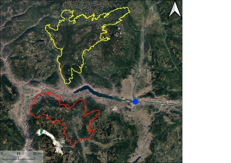
This study took place near Kamloops, B.C., Canada (50.6745° N, 120.3273° W), centering on 2 major wildfires that occurred in 2021 (Fig. 1). Situated in one of Canada’s hottest and driest regions, at elevations of approximately 1,000—1,700 m, the study area received an average annual precipitation of 341 mm, with 54 mm recorded during the 3-month study period (Environment Climate Change Canada, 2025; Weather Stats, 2025). During this time, temperature fluctuations in the area ranged from a high 47 ℃ to a low of 7 ℃, with highest average temperatures occurring in July (Weather Stats, 2025). Forests in this area are classified as having dry ecosystems, where historically, small “cool” forest fires occurred every 3 to 30 years, created a frequent low-severity fire regime that maintained local forest structure (Arsenault & Klenner, 2005; City of Kamloops, 2023). These conifer-dominated stands were comprised heavily of interior Douglas-fir (Pseudotsuga menziesii), lodgepole pine (Pinus contorta), ponderosa pine (Pinus ponderosa), and trembling aspen (Populus tremuloides) (University of British Columbia, 2023). However, in recent decades, increased fuel suppression efforts and the accumulation of dead-standing timber from mountain pine beetle have led to higher fuel loads, contributing to more frequent and larger wildfires, as well as an extended wildfire season into the fall (Government of British Columbia, 2021; Kreider et al., 2024; Woo et al., 2024).
_and_the_2021_tremont_creek_wil.jpeg)
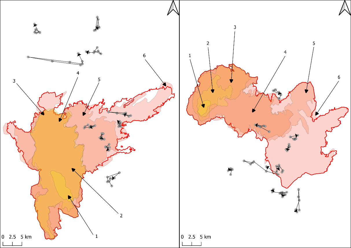
Two wildfires set the framework for this study: The Tremont Creek wildfire (50.6357° N, 120.9515° W) was located approximately 60 km southwest of Kamloops. The fire was discovered 12 July 2021 and burned a total of 63,548 ha (Government of British Columbia, 2021). The Sparks Lake wildfire (51° 3’ 36.324’’ N, 120° 47’ 30.624’’ W) located north of Kamloops, was discovered 28 June 2021, and eventually burned an area of 95,980 ha (Government of British Columbia, 2021). The ignition of this wildfire corresponded with a record-breaking heat dome event that took place from 25 June 2021 to 1 July 2021, causing extreme temperature highs (Bratu et al., 2022). The 2 wildfire perimeters were approximately 9 km away from one another.
METHODS
Animal Capture and GPS Data
Both the Tremont Creek and Sparks Lake wildfires coincided with research projects focused on understanding factors affecting moose populations and female moose reproductive success (Boucher et al., 2022; Procter et al., 2020; Roberge, 2023). At both sites, adult female moose had been previously captured by helicopter and immobilized using aerial darting systems (Pneudart Inc., Pennsylvania, USA; Dan-Inject ApS, Denmark). Individuals received 3.5 ml of BAM II (butorphanol 27.3 mg/ml, azaperone 9.1 mg/ml, medetomidine 10.9 mg/ml; Chiron Compounding Pharmacy Inc., Ontario, Canada), with effects reversed using naltrexone (50 mg/ml) and atipamezole (25 mg/ml). Moose were then fitted with either Vectronic Iridium Survey or Telonics TWG-4667-4 GPS collars following established handling protocols (Procter et al., 2020; Roberge, 2023) under authorization of the British Columbia Wildlife Act. Fix rate varied by study area; collars on moose in the Sparks Lake region collected a location every 4 hours, whereas collars in the Tremont Creek area collected a location every 2 hours. All collars were equipped with mortality beacons: if no movement was detected for 8 hours, a mortality signal would result, leading to a rapid site investigation to determine cause of death. All GPS location signals that failed due to communication issues with the satellites (rather than mortality) were identified as errors within the dataset and were removed.
Data Collection
GPS collar data for female collared moose within the proximity of the 2 wildfires in the Kamloops region were obtained from the B.C. Ministry of Water, Land, and Resource Stewardship (MWLRS). The Tremont Creek Site overlapped with a total of 10 collared adult females during the study period, including 5 whose locations overlapped the fire perimeter; all individuals from this site were included in analysis. In contrast, there were substantially more collared individuals at the Sparks Lake site. Data access for this analysis was limited to the subset received by MWLRS (n = 24). From this subset, we randomly selected 5 individuals whose locations overlapped the fire perimeter and 5 outside the fire perimeter using a random number generator to maintain balanced sample sizes between the fires.
Individual moose were classified into Position Categories, labeled as outside if none of their GPS data locations prior and during the fire events fell within any of the wildfire perimeter progressions. Conversely, animals were labeled as inside if any GPS data locations fell within the wildfire perimeter progressions. For 8 of 10 inside moose, >90% locations occurred within the fire perimeter, and 6 individuals had 100% of their locations inside the fire boundary (Table 2). Only 1 individual (M14) had substantially lower proportional exposure (15%).
This study was restricted to summer (defined here as 28 June – 20 September), as also defined for moose in interior B.C. by Francis et al. (2020). We categorized moose locations into 6 time periods (Table 1) during each wildfire, ranging in length from 4–26 days, with the majority being 4–6 days (86%). Duration of time periods was determined by the availability of representative fire perimeter shapefiles.
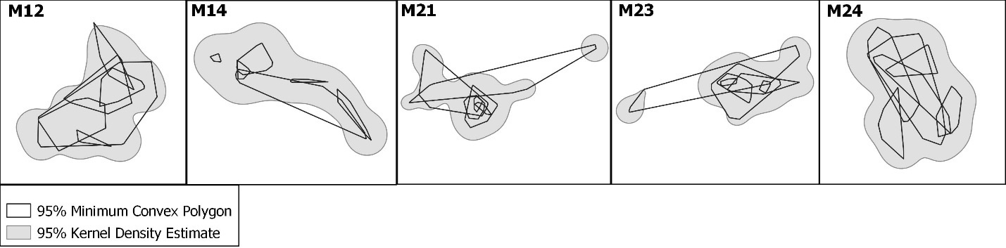
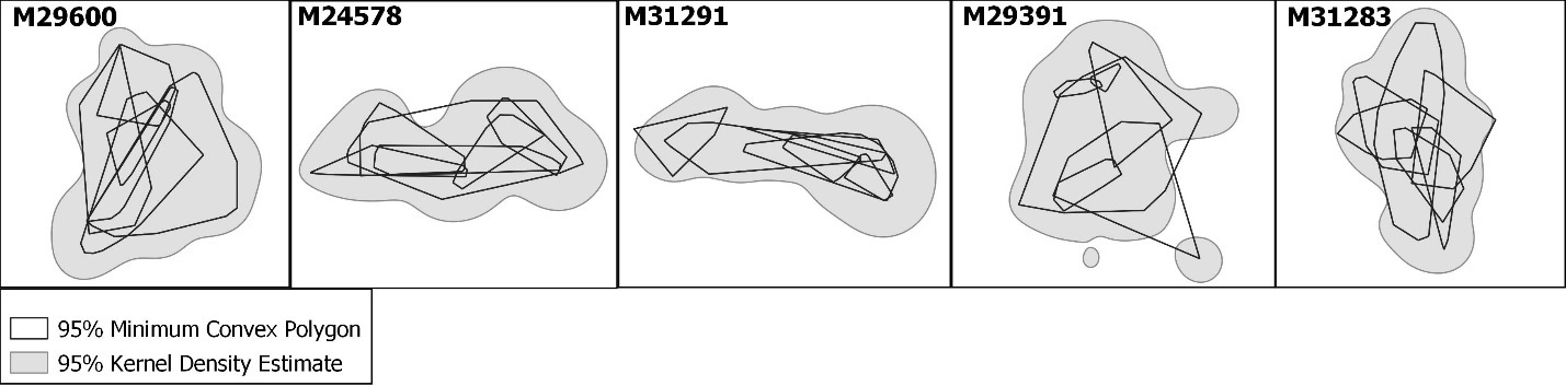
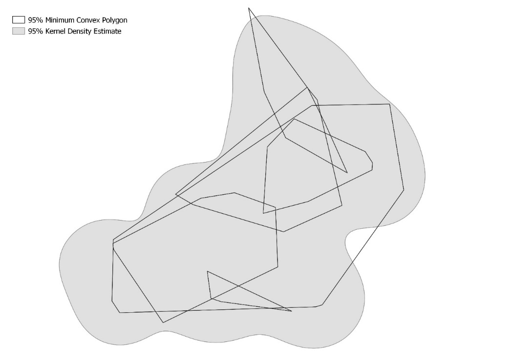
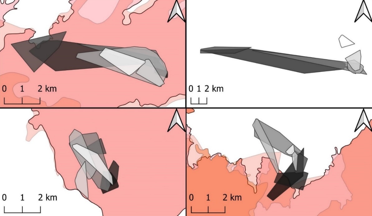
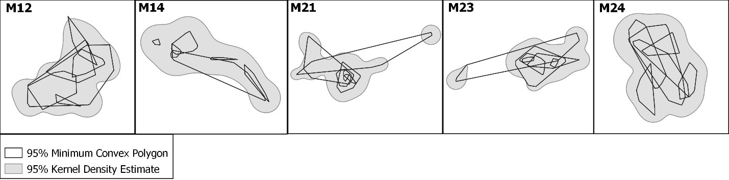
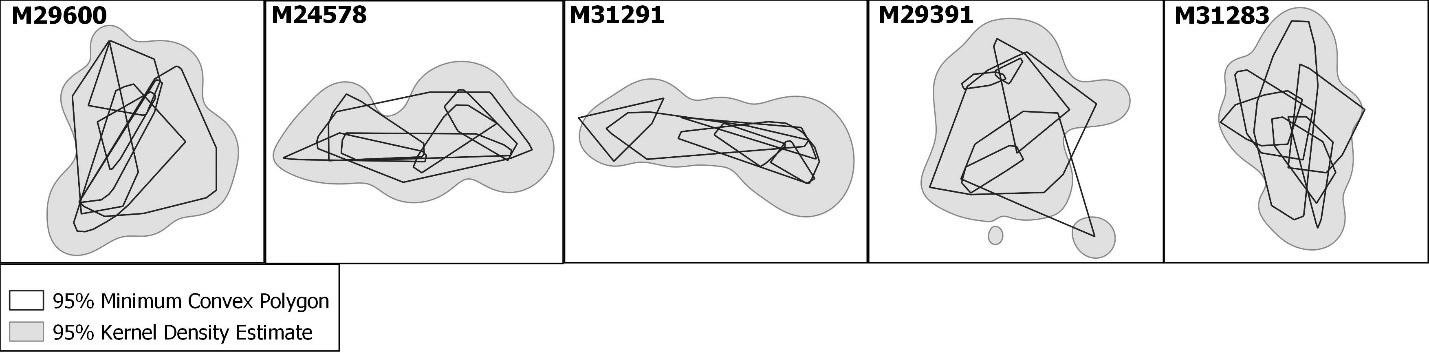
Using the location data for each moose, we calculated 5 movement metrics to represent behaviours of the moose before and during the fire: space use size, distance to the fire perimeter, consecutive space use overlap, overlap between space use and fire perimeter overlap, and step length. Short term space use was estimated using 95% Minimum Convex Polygons (MCPs) for each moose using the ade4 (Dray & Dufour, 2007), adehabitatHR (Calenge, 2006), and adehabitatMA (Calenge, 2006) packages in R (R Core Team, 2023) for each moose during each of the 6 time periods during the duration of the wildfires (Table 1). In addition, we created an MCP for each moose using locations from the 4 days prior to the wildfire ignition. To evaluate whether MCPs adequately represented short term space use, we compared them to 95% Kernel Density Estimates (KDE) derived from GPS locations throughout the entire study period. MCPs closely approximated KDE home ranges (Fig. 2), and patterns were consistent across individuals (Appendix Fig. S1 and S2). KDEs were also calculated in R (R Core Team, 2023) using the adehabitatHR (Calenge, 2006) packages.
_and_95__kernel_density_estimate_(kde)_home_ran.jpeg)
We quantified moose response to wildfire using 5 movement and space use metrics: (1) space use size, (2) distance to the fire perimeter, (3) consecutive space use overlap, (4) space use and fire perimeter overlap, and (5) step length. Collectively, these metrics described changes in the area occupied by individuals, their proximity to the advancing wildfire, the extent to which they shifted or maintained space use over time, and their movement rates within space use areas. Our objective was to evaluate space use level displacement rather than fine-scale movements of individual GPS locations to the fire perimeter. Accordingly, distance to fire was quantified using the centroid of each 95% MCP for each time period. This approach captured broad-scale shifts in space use areas over time. For all 5 metrics and for both fire areas, we predicted that differences would be observed between moose classified as being inside and outside the fire perimeter. We also predicted that all 5 metrics would change over time as moose became affected by the fire front, resulting from changing moose behaviour due to fire conditions (i.e., animals fleeing the fire front, as suggested by the “Bambi complex”).
Specifically, we calculated space use size (95% MCP, in ha) for each moose for each time period. Distance to the fire perimeter (km) was measured from the centroid of each moose’s 95% MCP to the nearest point of the associated fire perimeter for each time period. Negative values reflected space-use areas located within the fire perimeter. This metric was used to evaluate whether individuals shifted the spatial position of their seasonal home ranges relative to the expanding fire boundary. We calculated consecutive space use overlap (%) comparing the space use areas of 2 adjacent time periods to indicate if moose were adjusting the areas in which they were inhabiting as a result of the wildfire. Comparisons for time period 1 were made to the “before” MCP that was created for each moose during the 4 days prior to the start of the relevant wildfire (Table 1). The initial fire perimeter available for the Sparks Lake wildfire was 30 June 2021; therefore, data used for the 1st 2 days of the “before” MCP (June 26–27) overlapped marginally with what Francis et al. (2020) considered calving season for moose; however, we considered the minimal overlap too inconsequential to merit separate analysis. Space use and fire perimeter overlap were only calculated for moose classified as being inside wildfire perimeters, and were limited to time periods 3 through 6 because the wildfire did not encroach on existing moose space use areas until time period 3. This metric measured whether moose were increasing or decreasing their space use areas when affected by the wildfire. Finally, step length (m) was calculated as the distance between 2 consecutive GPS data points and provided a movement metric on whether individual movement rates varied with site, time period, or presence within the fire perimeter (Thurfjell et al., 2014). We calculated step lengths within each time period using the ade4 (Dray & Dufour, 2007), and adehabitatLT (Calenge, 2006) packages in R (R Core Team, 2023). For the purpose of the step length calculation, we subsampled Tremont Creek GPS data to align with the 4−hour fix rate at Sparks Lake fire; all other movement metrics for the Tremont Creek moose were based on a 2-hour fix frequency on the GPS collars. Mean step length was calculated for each individual for each time period.
Statistical Analysis
We used linear mixed-effects models to examine the main effects and all 2-way and 3-way interactions of position category (inside or outside the fire perimeter), time period, and site (Sparks Lake or Tremont Creek on the 5 different movement and space-use metrics. A code representing each individual moose was included as a random effect to account for lack of independence of measurements within individuals. Significant main effects and interactions were further analyzed using post-hoc pairwise comparisons with a Bonferroni adjustment to identify which groups differed significantly across time periods, site, or position category. All statistical analyses were conducted in R version 4.5.2 (R Core Team, 2023) using the lme4 and emmeans packages.
RESULTS
No mortality events among the 20 study animals occurred throughout the duration of the study (26 June 2021 – 20 August 2021). No individuals exhibited large, unidirectional movements indicative of temporary or permanent displacement from established seasonal ranges (Fig. 3, Fig. 4).
_and_tremont_creek_(right)_wildfire_progressions__occurring_in_interior_bri.png)
_and_tremont_creek_(bottom)_wild.jpeg)
Space use size
Space use size differed significantly between sites (F₁,₉₆ = 15.962, P < 0.001) and across time periods (F₅,₉₆ = 4.001, P = 0.002), with a significant interaction between site and time period (F₅,₉₆ = 3.536, P = 0.006) and between position category and site (F₁,₉₆ = 9.284, P = 0.003; Table 3). Post-hoc comparisons revealed that Sparks Lake moose had significantly larger space use sizes than Tremont Creek moose during time periods 1 and 4 (all P ≤ 0.001), whereas no significant site differences were observed during other time periods. In addition, outside moose at the Sparks Lake site exhibited larger space use sizes = 535 ha, SD = 537.4) than outside moose at Tremont Creek = 137 ha, SD = 106.5). Overall, these results indicate that space use size varied primarily by site and time period, with site differences most pronounced early in the study period (Table 4).
Distance to fire perimeter
Distance between space use centroids and the fire perimeter decreased across time periods (F₅,₈₀ = 95.225, P < 0.001; Table 3). Significant interactions were detected between site and time period (F₅,₈₀ = 19.500, P < 0.001) and between position category and time period (F₅,₈₀ = 2.834, P = 0.021). Post-hoc comparisons showed that Sparks Lake and Tremont Creek differed significantly during time period 1 (P = 0.0166), 2 (P = 0.039)0, 3 (P = 0.0205), and 6 (P = 0.0481), but not during time periods 4 or 5. Not surprisingly, moose classified as outside tended to be farther from the fire = 14.9 km, SD = 8.7) than moose classified as inside = 4.5 km, SD = 7.9), with the magnitude of this difference increasing over time (F₁,₁₆ = 21.675, P < 0.001). The significant position category × time period interaction indicated that the distance to the fire perimeter differed between moose located inside versus outside as the wildfire progressed; however, this reflects the expanding fire boundary rather than moose movement in response to the active wildfire perimeter (Table 4).
Consecutive space use overlap
Consecutive space use overlap did not differ between moose located inside the fire perimeter compared to outside (F₁,₁₆ = 0.172, P = 0.683). Overlap varied significantly across time periods (F₅,₈₀ = 12.570, P < 0.001), with a significant site × time period interaction (F₅,₈₀ = 3.074, P = 0.014; Table 3). Post-hoc comparisons revealed a significant difference between Sparks Lake and Tremont Creek only during time period 5 (P = 0.003; no other time periods showed significant site differences. These results indicate that changes in consecutive space use overlap were primarily driven by time period, with limited site-specific differences late in the wildfire progression, and that moose location relative to the fire did not significantly influence overlap (Table 4).
Space use and fire perimeter overlap
Overlap between moose space-use areas and the fire perimeter increased significantly across time periods (F₃,₂₄ = 22.239, P < 0.001; Table 3). No significant differences were detected between sites (F₁,₈ = 0.519, P = 0.492), and the interaction between site and time period was not significant (F₃,₂₄ = 1.857, P = 0.164). Post-hoc comparisons revealed significant increases in overlap during time period 4 (P < 0.001). Once space-use areas overlapped with the fire perimeter, all individuals except 1 remained within the fire boundary. These results indicate that increasing overlap was driven primarily by wildfire progression rather than by displacement of space use areas (Table 4).
Step length
Step length did not differ between moose located inside versus outside the fire perimeter (F₁,₉₆ = 0.003, P = 0.956), nor was there a significant main effect of time period (F₅,₉₆ = 0.839, P = 0.506). However, there was a significant effect of site (F₁,₉₆ = 7.362, P = 0.015) and a significant site × time period interaction (F₅,₉₆ = 3.715, P = 0.004; Table 3). Post-hoc comparisons revealed that Sparks Lake moose had greater step lengths than Tremont Creek moose during time periods 1–3 (all P ≤ 0.010), whereas no significant site differences were observed during time periods 4–6. Overall, step lengths generally were consistent across time periods, with site-specific differences occurring early in the study period (Table 4).
DISCUSSION
Moose inside the active wildfires did not reposition themselves into unburnt areas outside the fire perimeter, and largely maintained their original space use areas. An increase in space use size for moose inside the fire could have suggested attempts to avoid the progressing wildfire; however, our analyses indicate that space use size was primarily influenced by site and time period, with no consistent differences between moose inside and outside fire perimeters. Similarly, step lengths did not differ between the 2 categories of moose, and changes over time were largely site-dependent, meaning that moose did not alter their movement rates in response to the wildfire. As fires progressed, the distance to the fire decreased for moose within both fire areas, while moose outside the perimeter were farther from the fire, as expected. For the 10 inside moose, overlap between their space use areas and the fire perimeter increased as the wildfire progressed, peaking during time period 4, with only 1 individual reducing its space use within the fire perimeter. Overall, these results indicate that moose within fire areas maintained the same movement rates, space use size, and locations during the wildfire events. Thus, our data are inconsistent with the image implicit in the “Bambi complex” in which animals are imagined as racing ahead of the fire front. The overall undetectable response of moose to wildfire progression, combined with the lack of mortality during the wildfire, suggests that moose did not react to the fires as an immediate threat. Although it is possible that coarse fire perimeter data may obscure fine-scale behavioral responses, the GPS collar data and space use overlap metrics indicate that moose largely maintained their original locations and movement patterns even as the fire advanced.
Although differences between inside and outside moose were minimal, site-specific effects were notable. Moose at Sparks Lake exhibited larger space use areas and longer step lengths during early time periods than Tremont Creek moose. Moose space use is a function of resource availability and habitat heterogeneity across landscapes, which may indicate a habitat difference between the 2 areas, with moose at Sparks Lake having to take longer step lengths over larger space use areas to access resources and meet all survival requirements (Borowik et al., 2024; Van Beest et al., 2010). Despite the 2 sites being in within 9 km of one another and within similar forest types, it appears that landscape level effect, independent from the fires, influenced moose movement and behaviour.
Historically, dry forest types in this region experienced mixed-severity fire regimes which functioned to maintain vegetation composition and structural heterogeneity. However, these systems are now shifting toward regimes increasingly dominated by high-severity fires (Harvey et al., 2017; Heyerdahl et al., 2012; Parisien et al., 2020). In the case of the Sparks Lake wildfire, the areas in which the moose were inhabiting experienced relatively low-severity burning (Giles, 2021a); in comparison, the moose at Tremont Creek were situated in high-severity sites (Giles, 2021b). Lower severity may correlate with larger fire skips, cutblocks, and/or less fire crowning, which allowed moose to more easily avoid flames and heat. Yet, there was no difference in moose response between individuals inside and outside the wildfires at both sites, suggesting that severity was not directly responsible for moose behaviour during burning. Of note is the fact the study fires coincided with an extreme, record-breaking heat event in interior B.C. (Bratu et al., 2022). Moose are known to reduce movement rates and seek thermal refuge during periods of high temperature to mitigate heat stress, which may influence behavioural responses independent of wildfire effects (Alston et al., 2020). We cannot speculate on whether the combination of the extreme heat wave and the heat/danger from the wildfire interacted to influence moose movement.
The results of this study suggest a capacity of moose to survive a wildfire event even in dry forested areas in the southern portion of their range (Bergerud & Elliot, 1986). Moose are generally a boreal species, with their range largely being associated with boreal forest. In Canada, this ecosystem blankets a large portion of the land base from Newfoundland to the Yukon, and into the northern portion of B.C., where the majority of B.C.‘s moose population exists (Blancher et al., 2006). As such, the species is presumably adapted to the conditions and events that occur within the boreal forests, including prevalent wildfire (Pastor et al., 1988). This evolutionary history may contribute to the species’ tolerance of fire-prone environments as their range expands into the southern-interior forests of B.C.; however, it remains unclear whether adaptations to historical fire regimes will provide similar advantages under increasingly frequent high-severity fires (Bergerud & Elliot, 1986). We note that this study used fortuitous circumstances to document the response of moose to 2 fire events, albeit during extreme weather conditions, and our observations may not fully reflect long-term responses to changing fire regimes. Further serendipitous reports, under a wider range of ecological conditions, are needed to reveal the full scope and repertoire of moose behaviour.
Indirect and more subtle effects from wildfire on moose should not be disregarded. For example, the longer-term effects of exposure to wildfire (e.g. smoke inhalation, heat exposure) should be considered when examining potential impacts of fire. The increase incidence of wildfires in southern interior B.C. has been associated with an increase in overall temperatures during the critical summer period when traditionally moose struggle to stay cool (Carstensen et al., 2016; Haughian et al., 2012; Lenarz et al., 2009). Consequently, moose are confronted not only with wildfire itself but also with hotter, drier conditions and increased smoke exposure (Spittlehouse, 2008). As moose are a relatively new species within southern-interior B.C. (Bergerud & Elliot, 1986; Macgregor & Child, 1981), it is unknown how rapidly these changes within the environment will impact this species.
Although our study observed moose surviving wildfire events without major alterations to movement and space use, we caution that this does not imply the absence of responses. The use of fire perimeter data to estimate proximity to fire introduces uncertainty, particularly at fine spatial scales, and may not fully capture individual behavioral responses to fire severity or habitat heterogeneity. Using fire perimeters to define exposure to wildfire has limitations. Subtle or short-term behavioral responses may not be detected, and the spatial and temporal resolution of the fire perimeter data may not perfectly align with individual movements, meaning some fire-related behaviors could be missed. Further work is needed to investigate the specific tactics used by moose to survive and position themselves on a burning landscape, particularly in regards to different habitat types and burn severities. We urge that additional data be collected to document behaviour during other wildfires. Increased knowledge on this subject will aid in our understanding of the species and aid managers focused on conservation and management of moose in a landscape with increasing wildfires.
ACKNOWLEDGEMENTS
We thank the numerous partners who have supported the other ongoing projects that allowed for this project to take place, including funding provided by the Nlaka’pamux Nation Tribal Council, Teck Highland Valley Copper Partnership, Mitacs, Habitat Conservation Trust Foundation (HCTF), National Sciences and Engineering Research Council (NSERC), British Columbia Conservation Foundation (BCCF), the Association of Professional Biology (APB), the Ministry of Forests, the Ian McTaggart Cowan Professorship at the University of Victoria, Thompson Rivers University, and the Forests Enhancement Society of British Columbia. Additionally, in-kind support for this and related projects was provided by the B.C. Ministry of Water Land, and Resource Stewardship and Teck Highland Valley Copper Partnership.